
Danube Delta
Romania
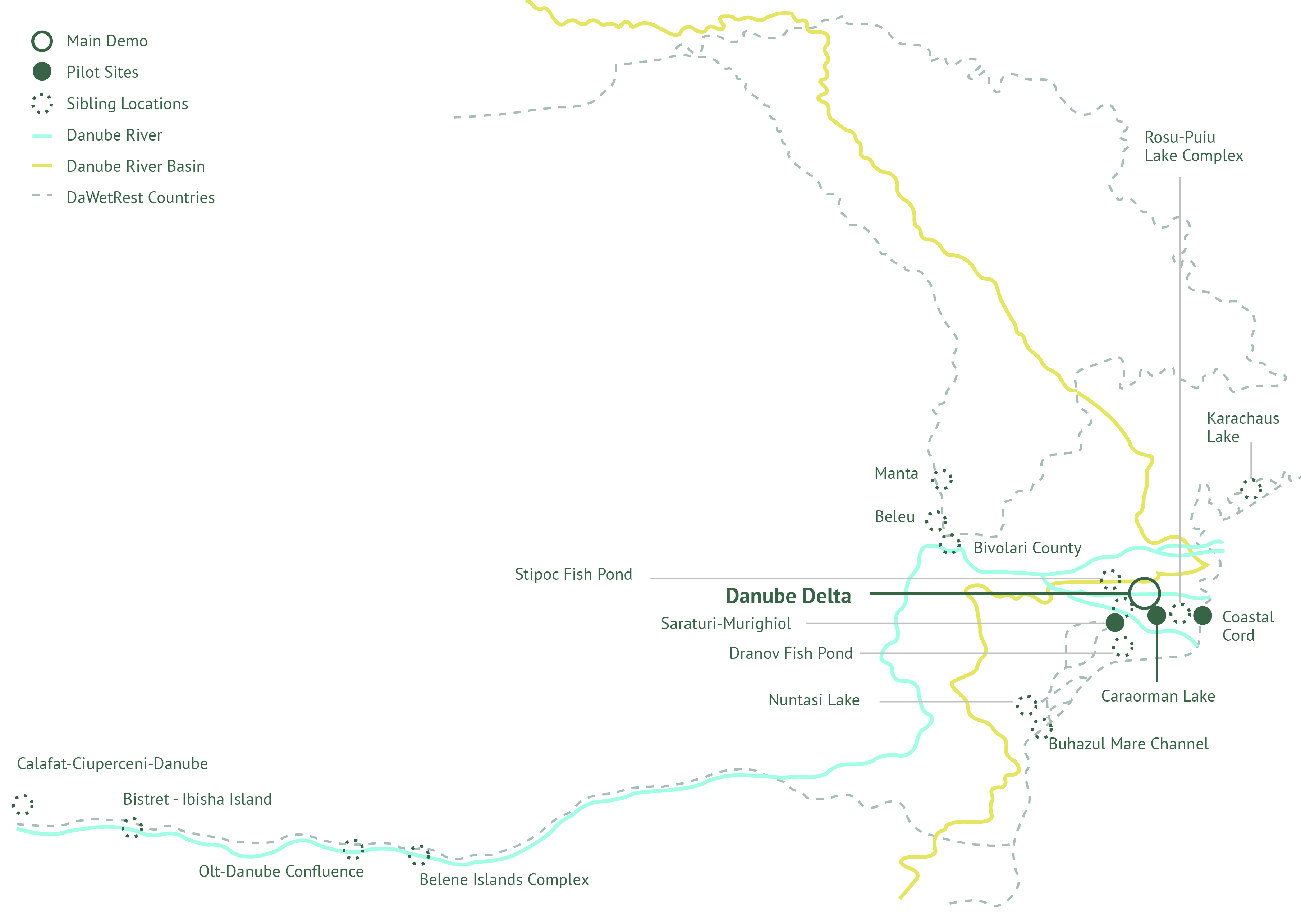
Lake Sărături Murighiol, Strictly Protected Area of Danube Delta Biosphere Reserve is located on the Danube terrace, has a length of approx. 2 km and a maximum width of 500 m. The waters here are strongly salinized by chloride sulfate type, characterised by the great richness of zoo- and phytoplankton. From the point of fauna view the area has an important ornithological role. Here they nest in numbers quite a lot of rare species of waders, among which the black-winged stilt (Himantopus himantopus) and Pied avocet (Recurvirostra avosetta) and also the lake shelters the nesting colonies of a large number of specimens of seagulls Larus ridibundus and L. melanocephalus as well as a Common terns (Sterna hirundo). During last years the lakes of Sărături – Murighiol became dried and the bird’s colonies and habitats were lost. The protection of discrete spatial areas such as salt-marshes can be present through a vertical connectivity by making the connection with the surface aquifer, being a challenge for the conservation of specific species. Such species can widely use disparate habitats and are vulnerable to anthropogenic impacts, which require both spatial and temporal considerations in planning and management. The restoration of the vertical connectivity and the water circulation in the Sărături – Murighiol Lake will be done based on the result from the hydraulic model. Geological and hydrological studies will be conducted in order to determine the depth of the ground water and amount of work needed to install the water pump station. After the implementation of the reconstruction strategy a surface totaling of 63 Ha will be reintroduced in the natural cycle. DD will restore the lateral connectivity of Caraorman Fish Pond and will implement an adapted, improved Recirculating Aquaculture System (RAS). DD will restore the coastal wetland in the area between Sulina and Sf. Gheorghe in the Black Sea Coastal Cord and by reducing hydrodynamic effects in Sărături Murighiol Lake to preserve and save the salt marshes’ habitats.
Main DEMO location
Danube Delta – Ramsar Wetland; part of UNESCO World Heritage Sites; part of UNESCO Programme on Man and the Biosphere; marked as Biosphere Reserve since 1998.
Pilot locations
Caraorman Lake to restore local ecosystems
Black Sea Coastal Cord area
Sărături Murighiol Lake
Sibling locations
Prut tributary
Lower Prut Floodplain
Roșu-Puiu lake complex
Olt-Danube Confluence
Calafat-Ciuperceni-Danube
Lake Călărași – Srebarna
Bistret – Ibisha Island
Lake Călărași – Srebarna and Suhaia – Belene Islands Complex
Beleu
Stipoc Fish Pond
Murighiol Fish Pond
Dranov Fish Pond
Buhazul Mare Channel
Nuntași Lake- Salt Marshes
Lake Velence
Actions

Improvement of hydrological conditions in wetlands, floodplains and coastal areas

Improvement of hydrological conditions in salt marshes

Strategy of the improvement of additional and sibling locations

Surface water quality monitoring system
Implementing Recirculating Aquaculture System (RAS) for improvement of water quality and environmental status
Reed management – holistic approach of reverting the ecosystem to the conditions prior to its disturbance & assessing potential of restoring carbon fluxes
Findings
Contribute to the European Green Deal, the EU Biodiversity Strategy, the EU Zero Pollution Action Plan and the Water Framework Directive as well as other EU instruments/policies on freshwater ecosystem protection

Contribute to the implementation of the protection and restoration of wetlands, flood plains and coastal wetlands and salt marshes

Reverse the deterioration of the state of wetlands, flood plains coastal wetlands and salt marches in the Danube River basin

Improve protection of local communities and ecosystems from extreme events (flood, droughts, storms)

Improved monitoring of carbon sequestration capacity of wetlands and coastal wetlands and salt marshes
Challenges
- During last years the lakes of Sărături – Murighiol became dried and the bird’s colonies and habitats were lost.
- The protection of discrete spatial areas such as salt-marshes can be present through a vertical connectivity by making the connection with the surface aquifer, being a challenge for the conservation of specific species.
- Such species can widely use disparate habitats and are vulnerable to anthropogenic impacts, which require both spatial and temporal considerations in planning and management.
- The restoration of the vertical connectivity and the water circulation in the Sărături – Murighiol fish pond will be done based on the result from the hydraulic model.
Innovative Solutions

Combined remote sensing, hydraulic modelling and in-situ monitoring

Reed management and monitoring for improved carbon sequestration
Improvement of hydrological conditions in lakes & salt marshes